


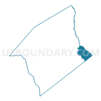
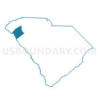
Friendship Voting District, Anderson County, South Carolina
About
Outline

Summary
| Unique Area Identifier | 664989 |
| Name | Friendship Voting District |
| County | Anderson County |
| State | South Carolina |
| Area (square miles) | 24.73 |
| Land Area (square miles) | 24.41 |
| Water Area (square miles) | 0.33 |
| % of Land Area | 98.68 |
| % of Water Area | 1.32 |
| Latitude of the Internal Point | 34.49201970 |
| Longtitude of the Internal Point | -82.38569590 |
Maps

Graphs
Select a template below for downloading or customizing gragh for Friendship Voting District, Anderson County, South Carolina


Neighbors
Neighoring Voting District (by Name) Neighboring Voting District on the Map
- Belton Voting District, Anderson County, SC
- Broadmouth Voting District, Abbeville County, SC
- Chiquola Mill Voting District, Anderson County, SC
- Dunklin Voting District, Greenville County, SC
- High Point Voting District, Anderson County, SC
- Princeton Voting District, Laurens County, SC
- Toney Creek Voting District, Anderson County, SC
Top 10 Neighboring County Subdivision (by Population) Neighboring County Subdivision on the Map
- Belton CCD, Anderson County, SC (14,457)
- Woodville CCD, Greenville County, SC (8,979)
- Honea Path CCD, Anderson County, SC (8,324)
- Princeton CCD, Laurens County, SC (6,514)
- Donalds CCD, Abbeville County, SC (3,254)
Top 10 Neighboring Place (by Population) Neighboring Place on the Map
Top 10 Neighboring Unified School District (by Population) Neighboring Unified School District on the Map
- Greenville County School District, SC (466,178)
- Laurens School District 55, SC (37,250)
- Abbeville County School District, SC (24,326)
- Anderson School District 2, SC (22,394)
Top 10 Neighboring State Legislative District Lower Chamber (by Population) Neighboring State Legislative District Lower Chamber on the Map
- State House District 28, SC (45,037)
- State House District 14, SC (33,392)
- State House District 7, SC (32,794)
- State House District 11, SC (32,278)
Top 10 Neighboring State Legislative District Upper Chamber (by Population) Neighboring State Legislative District Upper Chamber on the Map
Top 10 Neighboring 111th Congressional District (by Population) Neighboring 111th Congressional District on the Map
Top 10 Neighboring Census Tract (by Population) Neighboring Census Tract on the Map
- Census Tract 115, Anderson County, SC (6,283)
- Census Tract 32.02, Greenville County, SC (3,581)
- Census Tract 114.02, Anderson County, SC (3,368)
- Census Tract 9501, Abbeville County, SC (3,254)
- Census Tract 9202.01, Laurens County, SC (3,230)